Here’s Ten World Amazing Places that must be included in our New List of Wonder World.
1. Blue Lake Cave (Brazil)
The world famous "Blue Lake Cave" is a natural monument, whose interior is formed by stalactites, stalagmites and a huge and wonderful blue lake. The beauty of the lake is something impressive. The Blue Lake Cave has a big variety of geological formation but impresses mainly for the deep blue colored water of its inside lake.

2. Eye of the Sahara (Mauritania)
The Richat Structure is located in the center of Mauritania, the western end of the Sahara desert. It looks like an eye when seen from space and was first observed from space by Gemini 4 astronauts McDivitt and White in June 1965.
Most of the image looks yellowish, indicating sand desert. The dark brown part is bare sedimentary rocks, and within that you can see the Richat Structure, a gigantic ring structure of some 40 km in diameter. It is as large as Uchiura Bay in Hokkaido, Japan.
The part of the sedimentary rock corresponding to the white of the eye is a plateau standing some 200 m above the sand desert. The Richat Structure corresponding to the iris of the eye lies in a depression, and the peak of the outer rim is 485 m above sea level. The Richat Structure consists of Early Paleozoic rocks, some 600 million years old. Around the center, rocks resistant to weathering and erosion (purple and blue-green part) make 100 m high ridges, and nonresistant rocks (yellow and brown part) form valleys. These features alternate and are concentric.
The Richat Structure was previously thought to have been formed by metorite impact or volcanic activity, but field surveys have demonstrated that neither are correct. The current thinking is that these features were formed by an uplift and subsequent erosion from wind and water. However, why the structure is circular remains a mystery.

3. Giants Causeway (Ireland)
The Giant's Causeway (or Irish: Clochán na bhFómharach)[1] is an area of about 40,000 interlocking basalt columns, the result of an ancient volcanic eruption. It is located on the northeast coast of Ireland, about two miles (3 km) north of the town ofBushmills. It was declared a World Heritage Site by UNESCO in 1986, and a National Nature Reserve in 1987 by the Department of the Environment for Northern Ireland. In a 2005 poll of Radio Times readers, the Giant's Causeway was named as the fourth greatest natural wonder in the United Kingdom. The tops of the columns form stepping stones that lead from the cliff foot and disappear under the sea. Most of the columns are hexagonal, although there are also some with four, five, seven and eight sides. The tallest are about 12 metres (36 ft) high, and the solidified lava in the cliffs is 28 metres thick in places.
The Giant's Causeway is today owned and managed by the National Trust and it is the most popular tourist attraction in Northern Ireland.[2]

4. Antelope Canyon. Arizona – USA
Antelope Canyon itself is roughly five miles long, best done as two separate trips. Antelope runs north into Lake Powell, running between Page itself and the Navajo Power Generating Plant. This huge controversial plant, whose smokestacks do the Southwest no good, is at least a reliable landmark against getting lost while in the general area. At night its red aircraft warning lights can be a welcome orientation point. Fortunately, the plant sort of keeps to itself visually and aesthetically and so doesn't actually distract from hiking in the area. (Of course it is not visible while inside the twisting sandstone corridors of Antelope itself.)

5. Chocolate Hills (Philippines)
The Chocolate Hills is an unusual geological formation in Bohol, Philippines.[1] It is composed of around 1,268 perfectly cone-shaped hills of about the same size, spread over an area of more than 50 square kilometres (20 sq mi). They are covered in green grass that turns brown during the dry season, hence the name.
The Chocolate Hills is a famous tourist attraction of Bohol. It is featured in the provincial flag and seal to symbolize the abundance of natural attraction in the province.[2] It is in the Philippine Tourism Authority's list of tourist destinations in the Philippines;[3] it has been declared the country's 3rd National Geological Monument and proposed for inclusion in the UNESCO World Heritage List.[3]

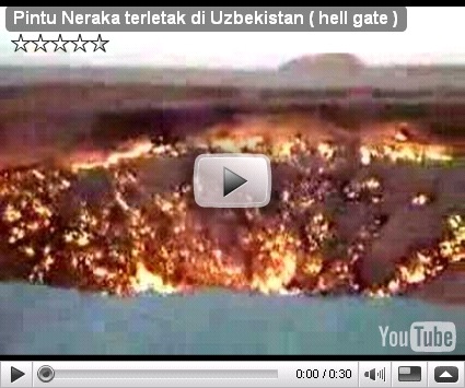
6. Hell Gate (Uzbekistan)
This place in Uzbekistan is called by locals “The Door to Hell”. It is situated near the small town of Darvaz. The story of this place lasts already for 35 years. Once the geologists were drilling for gas. Then suddenly during the drilling they have found an underground cavern, it was so big that all the drilling site with all the equipment and camps got deep deep under the ground. None dared to go down there because the cavern was filled with gas. So they ignited it so that no poisonous gas could come out of the hole, and since then, it’s burning, already for 35 years without any pause. Nobody knows how many tons of excellent gas has been burned for all those years but it just seems to be infinite there.

7. The Wave. Between Arizona and Utah – USA
The Wave is a sandstone formation on the slopes of the Coyote Buttes in the Paria Canyon-Vermilion Cliffs Wilderness, located in northern portion of the U.S. state ofArizona, just south of the Utah-Arizona border about halfway between Kanab, Utahand Page, Arizona.
This formation can be reached by hiking approximately 3 miles (4.8 kilometers) across rugged, trailless landscape, making the round-trip to and from The Wave a nearly 6-mile (9.7-kilometer) hike that climbs about 350 feet (107 meters) in altitude. Temperatures in this area easily climb above 100 F in the summer, so it is best to start the hike early. It is recommended to carry 1 gallon of water per person and lunch.

8. Great Blue Hole (Belize)
The Great Blue Hole is a large underwater sinkhole off of the coast of Belize. It lies near the center of Lighthouse Reef, a small atoll 100 kilometres (62 mi) from the mainland and Belize City. The hole is circular in shape, over 300 metres (984 ft) across and 120 metres (394 ft) deep. It was formed as a limestone cavesystem during the last glacial period when sea levels were much lower. As the ocean began to rise again, the caves flooded, and the roof collapsed.[1] It is part of the Belize Barrier Reef Reserve System.

9. Crystal Cave of the Giants (Mexico)
Found deep in a mine in southern Chihuahua Mexico, these crystals were formed in a natural cave totally enclosed in bedrock. When I first stepped into the cavern it was like walking into the Land of the Giants. I have often admired crystal geodes held in my hand, but when photographing these unique natural structures it was almost impossible to get any sense of scale. This is a geode full of spectacular crystals as tall as pine trees, and in some cases greater in circumference. They have formed beautiful crystals that are a translucent gold and silver in color, and come in many incredible forms and shapes. Some of the largest are essentially columnar in shape and stand thirty to fifty feet high and three to four feet in diameter. Many of the smaller examples are four to six feet in circumference, have many incredible geometrical shapes, and probably weigh in excess of ten tons. The columnar pillars are at first the most striking shape, but later I noticed there were thousands of "sharks teeth" up to three feet high placed row upon row and dispersed at odd angles throughout the caverns. While some of the crystals are attached to the ceiling walls and floors of the cave as might be expected, some exist in great masses of spikes and almost float in air. These crystals seem to defy gravity, as they must weigh several tons.

10. Wave Rock (Australia)
14 metres high, and 110m long, the face of Wave Rock appears ready to crash onto a pre-historic surf, now frozen in time.
Believed to have formed over 2700 million years ago, Wave Rock is part of the northern face of Hyden Rock. The shape of the wave is formed by gradual erosion of the softer rock beneath the upper edge, over many centuries. There are actually several examples of such "waves" in the Hyden area, and if you have the time, it is well worth the effort to see some of the other smaller, but equally spectacular, ones.
The colours of the Wave are caused by the rain washing chemical deposits (carbonates and iron hydroxide) down the face, forming vertical stripes of greys reds and yellows. If you can stay a little longer, it is also worth seeing the Rock at different times of the day, as the changing sunlight alters its colours and appearance.
In addition to being an impressive tourist attraction, the rock has been converted in to a catchment for the town's water supplies, with a foot-high concrete wall around the upper edge of Hyden Rock directing rainfall into a storage dam.


0 comments:
Post a Comment